
Region Wide Community Connectivity Study

A Path Forward on Emergency Egress and Emergency Preparedness:
Following the devastating 2023 wildfire season, including the fires that deeply impacted our neighbours in Upper Tantallon, it became abundantly clear that community connectivity is a critical matter of public safety. That is why, in March 2025, I moved a motion directing staff to complete a Region-wide Subdivision Egress Review Study.
Recently, staff returned the information report (report here, presentation here) was presented to Council, detailing the comprehensive findings of this initiative. I want to take a moment to break down what this means, and more importantly, what this means for District 13.
Understanding Our Vulnerabilities: The Community Connectivity Index
To assess our road networks, a consulting team developed the Community Connectivity Index (CCI). This GIS-based tool evaluated 362 subdivisions across the municipality based on three key vulnerability pillars
- Network Connectivity Index (NCI): Assesses how challenging it is to access roads, detour distances, and overall network redundancy.
- Social Mobility Vulnerability Index (SMVI): Examines demographic factors that impact mobility, such as low-income households, senior populations, or lack of vehicle access
- Geophysical Vulnerability Index (GVI): Estimates exposure to natural hazards, specifically wildfires and flooding.
What We Found: Highlighting Local Risks
The study confirmed what many of us have felt on the ground: historic coastal communities and expansive inland subdivisions are among the most vulnerable to access and egress challenges. Coastal constraints often mean long detour distances and single access roads. In fact, right here in District 13, Terence Bay ranked as the most vulnerable community in the entire region, with Prospect, Brookside, Westwood Hills, Sheldrake Lake, and Glen Haven West also appearing in the top 25.
Our Multi-Pronged Approach to Safety:
Addressing these risks requires a comprehensive strategy; we simply cannot build our way out of this issue. The report outlines three primary areas of intervention:
1. Roadway Infrastructure:
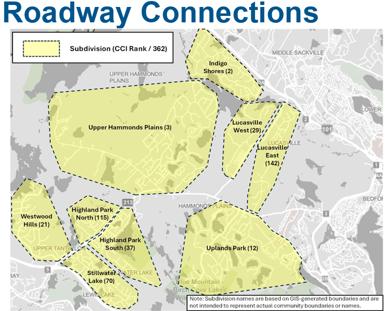
While new connections are being investigated for several high-priority areas, large-scale infrastructure expansion is complex and costly. However, staff will be conducting further investigations into potential roadway connections in vital areas including Upper Tantallon. Also, several communities outlined in this report are on provincial roads.
Additionally, further study is being conducted for communities like Westwood Hills and Stillwater Lake, as subdivision-level road connections alone don’t necessarily address broader connectivity constraints (regional road capacity).
2. Policy Improvements:
We must ensure that new developments do not repeat the mistakes of the past. The report recommends updating the Municipal Design Guidelines and the Regional Subdivision By-law to improve the clarity of existing standards, ensuring new subdivisions have truly independent and reliable street accesses. Future development approvals will need to factor in these connectivity constraints.
3. Emergency Planning and Preparedness:
For many of our coastal and remote peninsula communities, geographic constraints make new road construction unrealistic. In these areas, our focus must be firmly on preparedness. The Neighbourhood Emergency Preparedness Program (NEPP) is currently being piloted in places like Mason's Point, empowering residents to prevent, prepare for, and respond to emergencies. We will be looking to expand this community-led resilience program further across the municipality, and I look forward to introducing this to other communities in District 13.
A Unique Approach to Risk - What makes this study particularly groundbreaking is its incredible level of detail
While looking at what other municipalities across Canada are doing, researchers found that jurisdictions like Vancouver, Ottawa, and Edmonton regularly conduct Hazard, Risk, and Vulnerability Assessments (HRVAs). However, these are almost entirely focused at the broader district or regional level. They evaluate overall vulnerability to guide high-level policy or infrastructure investments, but they rarely zoom in to examine accessibility on an individual subdivision-by-subdivision basis. By mapping out the specific egress constraints, road redundancy, and social vulnerabilities of 362 distinct subdivisions, HRM is setting a new precedent. We are moving beyond broad municipal strokes to identify the exact neighbourhood choke points where residents could be at risk during an evacuation.
The Top 25 Most Vulnerable Subdivisions & Proposed Steps Through the Community Connectivity Index (CCI), the study identified the areas facing the highest combined risk from network limitations, geophysical hazards, and social mobility factors.
Here are the top 25, along with the specific mitigation steps and investigations currently being suggested:
- Terence Bay: Focus on operational readiness, emergency preparedness (NEPP), and targeted resilience upgrades to harden Terence Bay Road (e.g., vegetation management, flood-proofing) since new connections are geographically restricted.
- Indigo Shores: Investigating a multi-use pathway connection to Glen Arbour, or a gated emergency-only connection to Highway 101/Landfill Road.
- Upper Hammonds Plains: Investigating a community connector or emergency multi-use pathway between Westwood Hills and Upper Hammonds Plains/Pockwock.
- East Petpeswick: Focus on emergency preparedness, communication protocols, and evacuation planning due to coastal constraints.
- Prospect: Investigating a potential new connection to Prospect Road via Cannon Rock Lane and Brennan Road (Prospect-Shad Bay Link), alongside emergency preparedness programs.
- Porters Lake: Focus on emergency preparedness and operational response measures.
- East Chezzetcook: Focus on emergency preparedness and operational response measures.
- West Jeddore / Ostrea Lake: Focus on emergency preparedness and operational response measures.
- Springfield Lake West: Investigating a connection between Lakeview Avenue and Springfield Lake Road, as well as a multi-use pathway linking to Middle Sackville.
- East Jeddore: Focus on emergency preparedness and operational response measures.
- Fall River West: Investigating a roadway connection to Wellington to improve connectivity to the north.
- Uplands Park: Investigating a multi-use pathway linking to Highland Park and Stillwater Lake to serve as an active transportation and emergency route.
- East/West Pennant: Focus on emergency preparedness and operational response measures.
- Miller Lake: Investigating a gated emergency-only connection to Highway 118, or the extension of Perrin Drive to Aerotech Drive.
- Clam Harbour-Owls Head: Focus on emergency preparedness and operational response measures.
- Wellington West: Investigating a roadway connection to Fall River. 17.
- Brookside: Investigating a road connection between Irisweg Drive and Lynwood Drive, or an active transportation Brookside-Terence Bay connector.
- Bedford (Union / Nottingham): Proposing to upgrade the existing multi-use pathway between Shaffleburg Run and Bainview Drive to support emergency vehicles.
- Mainland Common: Focus on policy improvements, ensuring future density addresses connectivity limitations.
- Sheldrake Lake (Lake of the Woods): Investigating the formalization and improvement of the trail between Silver Birch Drive and Cambren Drive into a multi-use pathway.
- Westwood Hills: Proceeding with the approved emergency egress road to Highway 103, and investigating a connector to Upper Hammonds Plains.
- Glen Haven West: Focus on emergency preparedness and operational response measures.
- Conrod Settlement: Focus on emergency preparedness and operational response measures.
- Greystone Drive: Focus on policy improvements and emergency preparedness.
- Eider Drive: Focus on emergency preparedness and operational response measures.
Our Multi-Pronged Approach to Safety:
As you can see from the list above, addressing these risks requires a comprehensive strategy. For our inland communities, we are pursuing Roadway Infrastructure improvements—finding those critical missing links to create secondary exits. However, in many coastal and remote peninsula communities, geographic constraints make new road construction unrealistic. In these areas, our focus must be firmly on Emergency Planning and Preparedness, including the expansion of the Neighbourhood Emergency Preparedness Program (NEPP) to empower residents, and further promoting FireSmart within communities.
Finally, sweeping Policy Improvements to our Municipal Design Guidelines will ensure that new developments do not repeat the single-access mistakes of the past.
Looking Ahead:
Community safety remains my top priority. By combining strategic infrastructure investments, smarter planning policies, and community-led emergency preparedness, we can build a more resilient region. I will continue to advocate for these vital improvements as Council considers the next steps in capital funding and policy updates.